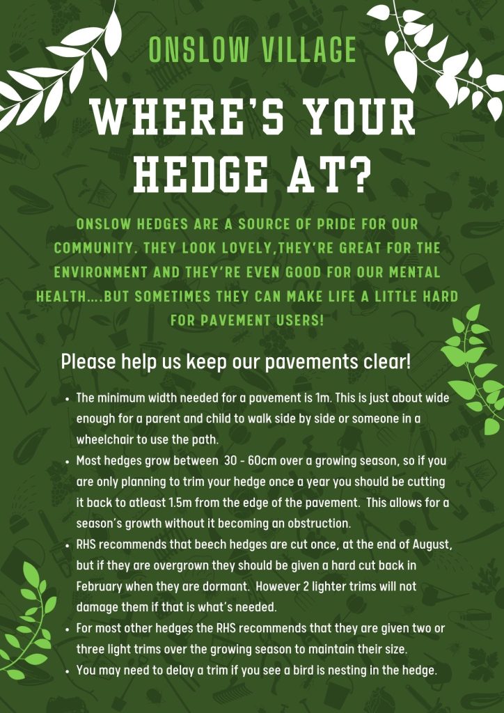
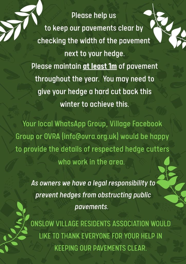
The Hedge Campaign flyer
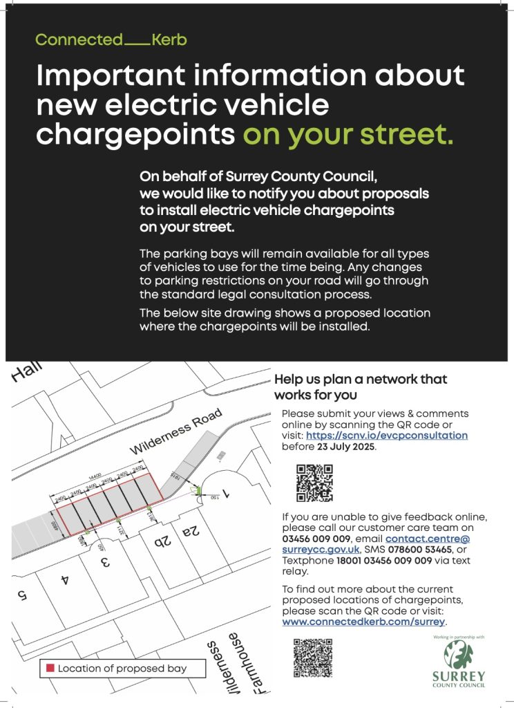
Electric Vehicle Charging Point
Consultation
North Street Development Community Update Briefing June 2025
University Research Project
Bin Collection Calendar 2025
Look out for hornet nests
Yellow Legged Asian Hornets Alert
Winner of Treasure Trail 2024
Wood Burning – Report on APRIL meeting
Loseley Path Update (May 2026)
We are delighted to announce that the path across the top of the Loseley fields on the south side of The Mount has now officially re-opened.
In order to protect the crops the estate will be installing a fence along the length of the path. This will be simple stock fencing with plain wire above it, which will not interfere with the view but will mean dogs can run freely along the path. However until the fence is installed please be respectful of the farmer’s crops and keep dogs on a lead.
The path starts at the beginning of the field at the top of The Mount, and finishes at the mast enclosure. This is shorter than the previous path but represents the compromise between the farmer’s needs and those of the community. It reverts to the stretch that was walked pre 2008 when there was livestock in the field by the masts and the public had no access.
It is a Permissive Path which makes it easier for the Estate to manage access in response to farming needs and does not introduce long term legal liabilities and operational constraints. It does not mean that Loseley intend to close it in the future. They are hoping that their willingness to fund a fence demonstrates that they are committed to keeping the path open in the long term and they hope everyone will enjoy the path as much as they have always done.
The OVRA Committee are very happy with the outcome and feel it is a genuine win/win outcome for all. We consider our work done and are thus withdrawing from the Steering Group. We thank the Steering Group for all the hard work that they put in behind the scenes to bring about this happy conclusion. We are now excited for a new and better relationship with Loseley and look forward to sharing the first of their regular updates, letting us know what’s going on around the Estate.
Jim Heroys, the Estate Manager, has already sent two documents to share with our communities. One gives the news outlined above, and the other explains a little more about the temporary closure of the Permissive Path between the North Downs Way and the footpath which runs in front of Loseley house and next to the lake. Both of these documents can be found below.
We hope you will join us in our gratitude to Loseley for continuing to share this beautiful walk with us, and we trust that everyone will use the path respectfully and responsibly.
The Hedge Campaign
Electric Vehicle Charging Point Consultation
Finishes 23rd July 2025

North Street Development Community Update Briefing
The slides from the event can be seen here.
Building/Scheme Notes
- Building works have commenced and will continue until December 2030
- Demolition of the two buildings on North Street has commenced
- Piling works have commenced
- The first new building is planned to be completed by May 2026 and will initially be a sales suite for the new apartments. It will contain 8 apartments.
- No info on apartment prices has been released as yet. Apartment sales are expected to commence in November 2027
- Some building heights have changed, some down by a metre, while some have increased by 1.5 metres – Subject to planning being approved in December this year.
- Other changes include – An additional lift being added to each building, due to changes in building regulations, more trees and soft landscaping has been added, a small amount of public realm space has been added.
- 477 new homes will be built. Approximately 850 residents will live in the area, injecting “life” into the town centre. They are expected to spend around £8,000 per head per year, adding £6.5m of additional spending into local shops and businesses.
- The new pedestrianised area will stretch from Black Sheep Coffee to Poundland on North Street
- Only two new buildings will be created on North Street. Poundland and Barclays will remain, as St Edward does not own these buildings. The facades of both buildings are expected to be refreshed by their owners, so they blend in. expected to
- St Edward is now working with the NHS in specifying the requirements for the medical centre. What this centre will offer is not yet known. It will be a 350 metre square building.
- Two acres of new public realm space will be created
- £4m is being spent on the bus station rebuild. The new station will have fewer bays; however, buses will be able to access from the North and the South, speeding up access for buses, so they will be able to move through the station more quickly. Therefore less need for parking bays. The station will feature waiting rooms and toilets.
- The roads leading into the station are being realigned to make it easier for buses to turn/turn around
- Two new temporary bus stops are being added to North Street to ease congestion and bus offloading during the bus station rebuild
- The bus operators have all been engaged in the design process.
- The current bus station canopy demolition will be completed in December this year.
- The new bus station is due to be completed by the end of 2026
General Notes
- There is little of archaeological interest on the site, as this was mostly destroyed when the Friary Centre was built. All the ground west of Woodbridge Road has been surveyed, with nothing of note found. St Edward has worked in tandem with local historians and archaeologists in these efforts.
- Any interesting building features in the demolished buildings will be passed to local museums. Demolition will be completed in June.
- St Edward is offering summer placements for local school students interested in working in construction
- The North Street market will be temporarily relocated to outside the library while being built. It will return to the bottom of North Street after the building work is completed
- There are plans for monthly community events in the area once it’s completed, as a way to create a thriving and engaged community in the area.
Outstanding Issues
- How the Section 106 funds (given to local council as part of the planning arrangements to fund local projects) will be spent is not clear as yet. A large chunk will be spent on the medical centre, but OVRA members might want to ask our local councillors what the plans for the rest of these funds are?
- I was disappointed that no Guildford Borough councillors attended this briefing. However, St Edward said that they are working very closely with the Council and the planning officers through weekly meetings.
Opportunity for Local Change: St Edward’s £10,000 Community Fund Now Open
Take part in a University of Surrey paid Research Project!
Psychology researchers at the University of Surrey are seeking 7-10-year-old children and their parent/guardian to participate in paid research (£50 voucher). The study involves a presurvey and a lab session at the University of Surrey (travel costs reimbursed). For more information and click here.
Bin Collection Calendar

Look out for hornet nests!

Yellow Legged Asian Hornet Alert
A destructive, and potentially dangerous, invasive insect has made its way to the UK and may soon be in Guildford.
Read on to find out how to spot it, how you can help stop it…and how to keep yourself safe.
Yellow-Legged Asian Hornets have the capacity to wreak havoc on our wildlife in the UK. One nest of hornets can consume up to around 11kg of insects in a year; honey bees generally make up 60% of their diet. We all know just how important pollinators are to our own health and wellbeing, and the security of our food chain. This could have huge consequences on our wider ecology and a devastating impact on song birds that rely on insects for food.
Yellow-Legged Asian Hornets could pose a risk to public health too. While one hornet alone is unlikely to cause a problem, they can be aggressively defensive of their nests, which can be built high in trees but also low to the ground and in hedgerows and brambles. Do not approach a suspected nest closer than 10m.
Please take time to familiarise yourself with what they look like, download the free government Asian Hornet Watch App, then report any suspected sightings. Or call our local member of the Asian Hornet Alert Team on 07966 182171 or email gillie.muir@gmail.com. Gillie can help verify photos. If it’s a positive, a team of government bee inspectors will come to locate and destroy the nest.


Other useful websites:
National Bee Unit website: https://www.nationalbeeunit.com/diseases-and-pests/asian-hornet/
Non-Native Species Secretariat (nest identification): https://www.nonnativespecies.org/non-native-species/id-sheets/asian-hornet-nest-identification/
British Beekeepers’ Association website: https://www.bbka.org.uk/Listing/Category/asian-hornet-vespa-velutina
Winner of the OVRA Treasure Trail 2024 Prize Draw
Congratulations to Zoe Lowres (aged 10) who was the lucky winner of the Treasure Trail Prize Draw. She receives a £25 Odeon Cinema Voucher. Well done to everyone else who completed the trail and sent in their entries.
The Treasure Trail will continue to be available to download from the Events page of this website. All the clues relate to permanent features in the village so it can be done at any time. Many thanks to all the people who have let us know how much they have enjoyed doing it.
Look out for a new trail next summer!
Wood Burning – report on APRIL meeting, 29/7/24
By Alan Robins
APRIL
APRIL (‘Air Pollution Research in London’, https://aprilresearchlondon.wordpress.com) is a network that brings together scientists, policy-makers and the wider community to share the latest science and knowledge about air pollution and to discuss priority areas for future research, mitigations and actions to improve air quality, as well as exploring opportunities for collaboration. Regular meetings are held in central London and co-ordinated by the Greater London Authority, alongside members of the Committee.
Background to the meeting
Regulating authorities have considerable difficulty in assessing pollution from wood burning – the essential issue is that emissions from each source may be small but the combined emission large, further that there are no common emission systems, in the sense that chimney stack and flue designs are very variable. For example, the fact that odours from near-by wood burning appliances are frequently detected at street level testifies to the inadequacy of stack design.
The main pollutant of concern that is emitted by burning solid fuels such as wood is ultra-fine particles, also known as PM2.5 (Particle Matter less than 2.5 micrometers in diameter). It is widely acknowledged as being the air pollutant which has the greatest impact on human health, as it penetrates deeply into the lungs. Both short and long-term exposure to PM2.5 increases the risk of early deaths from respiratory and cardiovascular diseases as well as hospital admissions. Children growing up exposed to PM2.5 are more likely to have reduced lung function and can develop asthma. Current evidence suggests there is no safe level.
Government statistics show that domestic wood burning accounted for 25 per cent of PM2.5 emissions in 2020 [1]. Emissions from domestic wood burning have increased by 35 per cent between 2010 and 2020 and become the single largest source of fine particle air pollution in the UK, exceeding that of road traffic [2].
The best way to reduce exposure is to stop burning or reduce the amount burnt. Fuel and burner selection make a big difference to the pollution created. Open fireplaces are the most polluting and pose the greatest risk to health. Since January 2022, all new wood burning stoves must meet new EcoDesign standards. Even so, Ecodesign wood burning stoves produce up to 450 times more toxic air pollution [3] than gas central heating, according to data published in the Chief Medical Officer’s Annual Report 2022.
The control of wood burning is clearly an important issue in improving urban air quality and was the driving force for the meeting.
APRIL meeting on air pollution from domestic wood-burning.
The meeting was hosted by Camden Borough Council. All the presentations are available on-line at the APRIL website and include links or references to original sources and reports.
This is a summary of my notes from the meeting.
1. Robert Stewart (Ricardo): “Air emissions from solid fuel stoves and fireplaces – the Defra Emission Factors for Domestic Solid Fuel Project.”
Emission factors are used to estimate the rate at which pollutants are emitted from any particular activity.
About a hundred combinations of fuels, appliances and procedures were tested. A typical appliance was selected from each of:
- an open fire
- a pre-2000 closed stove
- a 2000-2009 closed stove
- a modern stove (2022, Ecodesign-compliant),
and for fuels:
- dry wood (commonly available ‘kiln dried’ wood supplied in sealed plastic bags), 6% moisture content
- seasoned wood (seasoned in-house), 15% moisture content targeted
- wet wood (representative of wood stored in outdoor/wet conditions), 25% moisture content targeted.
The emission rates of many regulated pollutants, including PM2.5, were measured in laboratory conditions and expressed in terms of mass emitted per unit of energy supplied.
The modern stove performed better than all others and the use of seasoned wood was clearly best for most pollutants, including PM2.5 but, as already noted, all were much more polluting than gas burning.
2. Tim Williamson (Air Quality Consultants): “Measures to reduce PM2.5 from domestic combustion”
The results of an EU study were summarised by a selection of case studies illustrating procedures in EU countries. The aim was to identify effective measures to foster “burn better, burn less” and dealt with:
Stock – replacement of older appliances,
Restrictions – limitations or prevention of use,
Awareness – burn better, burn less.
There was considerable variation from country to country, reflecting traditional practices as well as practical issues, though appliance replacement schemes were widespread. Germany was a particularly interesting example, where burn better was the focus, with emphasis on regular maintenance by certified engineers and training schemes for users, described as a licencing process.
There was much from these studies that could be adapted as best practice in the UK.
3. Gary Fuller (Imperial College London): “Investigating PM from wood burning in London”
Having been out of favour since the introduction of the Clean Air Act in 1956, wood burning began to return to fashion in the 2010s, but not driven by necessity [4]. Its growth could be viewed as a social issue. In the UK 8% of homes are now responsible for 27% of primary PM2.5 pollution – primary, because fine particles can also be created through chemical reactions in the atmosphere.
The investigation covered a number of areas of impact: indoors, local, neighbourhood and city. The local scale, measured by tens of metres from the source, was the scale of greatest impact outdoors, with pollution peaks associated with start-up and refuelling.
The lack of ‘affordable’ instrumentation for measuring pollution specifically from wood burning was seen as a major barrier to mapping and understanding the distribution of pollutants, particularly at the local scale.
Climate impact was also discussed, noting that wood burning was generally not carbon-neutral over decades, but over centuries.
4. Huw Woodward and Matheus Almeida (Imperial College London and University of Bristol): “High resolution modelling of PM2.5 from domestic wood-burning in urban areas”
This work illustrated very clearly the difficulties that regulating authorities have in assessing pollution from wood burning.
Combinations of ‘open-fire, basic, enhanced and best’ appliances were treated. The combined pollution levels from a number of randomly placed ‘wood burning’ buildings were mapped over the local neighbourhood. The conclusion was simple, as a minimum, standards had to reach 100% Ecodesign levels, with open fire and basic appliances removed from service.
Notes
1. Strictly speaking from solid fuels – but by far the largest component is from wood.
2. The uncertainty attached to the figures for wood burning are quite large – it might be best to think of total traffic and wood burning emissions of PM2.5 as broadly similar. This uncertainty is one of the key problems in developing strategies to meet PM2.5 targets.
3. That is PM2.5 emissions per unit of energy supplied.
4. Some wood burning can also be a result of fuel poverty.